The information in this web site is shown on a map of the village. Here’s how to use it
- Go to the MAP item on the main menu to launch the map.
![]()
-
- You’ll get a display like this – see the explanation below of the numbered controls:
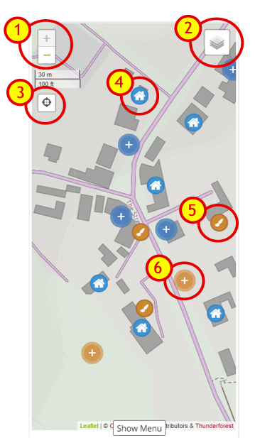 |
1. ZOOM control – Click either “+” to ZOOM IN – ot “-“to ZOOM OUT. On a mobile device you can also zoom by “pinching in” or “pinching out”. On a desktop device with a mouse you can also use the scrollwheel to zoom in/out. |
2. LAYER control – click this to see the layer you can display: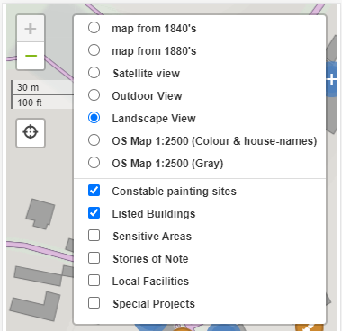 From the TOP PART select the BACKGROUND MAPÂ you want (note theere are historical maps back to 1840!)From the BOTTOM PART select which ITEMS you want to be OVERLAID, (e.g.: “Constable’s Paintings Sites, “Listed Buildings ” etc.) From the TOP PART select the BACKGROUND MAPÂ you want (note theere are historical maps back to 1840!)From the BOTTOM PART select which ITEMS you want to be OVERLAID, (e.g.: “Constable’s Paintings Sites, “Listed Buildings ” etc.) |
|
| 3. LOCATION (SATNAV) control – click this to see your current position on the map, (only shown for mobile devices with GPS posotioning). Note the first tiem you do this your mobile device will probably prompt to “Allow to use Location Services”. You say Yes obviously! | |
| 4. MARKER (HOUSE) – A BLUE marker with a house on it shows the locations of our Listed Builgings. Click to show the details. | |
| 5. MARKER (CONSTABLE PAINTING) –Â A BROWN marker with a paint brush on it shows the site John Constable used for one of his Landscape paintings. Click on it to show details. |
So that’s the basics of getting around the map – “Simples” Eh. We hope you can now enjoy your virtual tour of our historic village