
Area B covers Gastons End, one of the satellite hamlets to the medieval village of East Bergholt, bordering a triangular green at the northwestern tip of East Bergholt Heath.
Area C covers a large part of the extensive East Bergholt Heath and played a significant part in the development of the settlement pattern within the parish.Â
Area D is the East Bergholt windmill which played an important part in the development of John Constable as an artist.Â
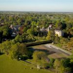
The East Bergholt Conservation Area encompasses an area of land bordering Gaston Street, The Street and Rectory Hill, between the two main settled parts of the village. The Conservation Area is wholly within the Dedham Vale AONB.
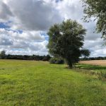
The Donkey Track is a long-established footpath which runs northwards from Gandish Road across what was originally the village "heath" or "common".
To the south-west of the track, the undulating land is divided by the Riber stream which continues across Rectory Hill and eventually down to the Stour.
The western boundary is created by the rear of The Old Rectory and properties which face Rectory Hill, The Street, and Gaston Street.
The north-eastern side of the track is distinguished by a 20-year-old woodland at the southern end leading to cultivated fields divided by hedges leading up to Heath Road/Mill Road, the main vehicular route around East Bergholt. The rear of the 1970's Richardson Road estate and the Medical Surgery complex abut the land to the north.