Items:486
Page: 1 2 3 17


This section runs from the village centre at the Gaston Street junction, from The Gables* along the western side of Hadleigh Road to the junction with Hughes Road (* The Gables is a listed building which sits in the current Conservation Area).

While the eastern side of the road is not for conservation area consideration, (mainly lined with set-back 20thC and 21stC houses and the school playing field), it does contribute to the attractive natural tree cover that characterizes the road.

Together with the western side, the mature trees create a pleasing “tunnel” effect over the road at all seasons. The tree-lined frontages for historic buildings such as Gatton House and Ackworth House, which are spaced out along the road, with driveway entrances such as the one for the Gattinets business units. Generally, these historic buildings are only partly visible from the road where the vegetation predominates, with no pavement on this side.

At the top Hadleigh Road intersects with Hughes Road and Elm Road, before it continues northwards. Here there is a large open meadow in front of the historic Allens Farmstead, and features the gated drive to the Grade 2* -listed “The Lodge”, which is not really visible from the road.

 
Moat, unoccupied, wet (on banks of R Stour).
 
Ring ditch, circa 15m in diameter, with at least one internal feature(?)(S1).
 
Flint scraper. Formerly recorded as EBG MISC
Historic Record
Flatford Mill
 
Watermill on River Stour, famed for connections to (and paintings by) John Constable. listed building
 
Bronze sestertius, possibly of M Aurelius, found metal detecting (S1) within area of Undated field system cropmarks. And a possible dupondius.
 
A flood defence bank of probable Post-Medieval date is visible on aerial photographs of East Bergholt parish
 

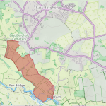
Flatford itself is a small cluster of buildings on the banks of the River Stour to the south of East Bergholt. It includes the famous Flatford Mill, together with other historic structures such as the lock, the bridge, the Granary, Valley Farmhouse and Willy Lott’s Cottage.

It is served by Flatford Lane on the north side of the river, which runs in a loop from the crossroads at Gandish Road/White Horse Road junction downhill towards the National Trust CarPark, and then uphill to East Bergholt Church.

The area is within the Dedham Vale AONB; with cross-country pedestrian and boat access to Dedham itself. The land for consideration for Conservation Area status also comprises the fields and woods either side of Flatford Lane, and the mill-related properties on the riverside.

 
Reputed chapel site said to be visible as cropmark at TM 078 334 (S1). Not substantiated. Formerly recorded as EBG MISC
 
Curving trackway cropmark (S1) W end cut by modern reservoir/lake but probably led to moat EBG 001.
 
Archaeology in Suffolk 2016
 
Site of bridge over the River Stour shown on Hodskinsons map of 1783.
Historic Record
Lattinford Hill
 
Metal detector finds of bronze coins: sestertius, C1/C2; AS, C1; ?Dupondius, C1/C2.
 
Cropmarks of rectilinear ditch systems, trackways, ? ring ditch, circa 16m in diameter (S1)(S2).
North of Hadleigh Rd, between Hughes Road and the A1070 Heath Rd

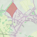
The northern part of Hadleigh Road runs between Hughes Road and the A1070 Heath Road.

On the eastern side, set well back is a line of several bungalows leading to a cluster of 2-storey houses from the 1970’s and ‘80’s in Collingwood Fields. This  eastern side is not under consideration for the Conservation Area. It is the large field opposite on the western side which needs some protection.

The agricultural area under consideration runs from the tree-and-hedge-lined edge of Hadleigh Road up to the dense linear block of woodland running  from a bend in the A1070 to The Lodge entrance on Hughes Road, and south, but parallel to the A12.

 
Dodnash Priory, Augustinian, founded 1188, dissolved 1525.- Scheduled Monument
Historic Record
Old Hall
 
Bank circa 6-7 feet high to E of `Old Hall, semi-circular, close to being circular.
Historic Record
Lattinford Bridge
 
Sherds, brick fragments, animal bone.
 
Site of bridge shown on 1880s OS map where named Fen Bridge. Crosses tributary of River Stour.
Historic Record
Lattinford Hill (Rom)
 
Metal detector find of bronze coin, AS of Vespasian of AD 71.
 
Traces small rectilinear enclosure or field system, S of ?Rom road, EBG 002 (S1).
 
Church, churchyard and separate bell cage of St Mary the Virgin. Possible Domesday minster site.
 
Earthwork banks 2m high surrounding 55m by 35m enclosed oval area.
 
Domed lead spindle whorl (S1).
 
Farm buildings shown on 1880s OS map.
 
Metal detector find of bronze coin - sestertius of Commodus (AD 180-192), rev illegible, very corroded. Possible Late Saxon decorated bone comb
 
Human skull found in road widening spoil opposite the Carriers Arms.
Achaeological Site
test 2
 
 
Square, flat, bronze (copper? - reddish metal) mount with enamelled front.
 
Monitoring revealed two small undated pits that contain burnt flint.