Better known now as "Touchy Lane", "Procession Lane" originally a footpath connecting the top of Touchy Hill with East End.Â
The Donkey Track is a long-established footpath which runs northwards from Gandish Road across what was originally the village "heath" or "common".
To the south-west of the track, the undulating land is divided by the Riber stream which continues across Rectory Hill and eventually down to the Stour.
The western boundary is created by the rear of The Old Rectory and properties which face Rectory Hill, The Street, and Gaston Street.
The north-eastern side of the track is distinguished by a 20-year-old woodland at the southern end leading to cultivated fields divided by hedges leading up to Heath Road/Mill Road, the main vehicular route around East Bergholt. The rear of the 1970's Richardson Road estate and the Medical Surgery complex abut the land to the north.

Charming Tea Room in the centre of the village, near public car park.Â
Call and collect mobile catering at weekly destinations, rotating themed menus and Sunday roast collections from the Chefneil Kitchen
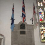
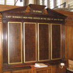
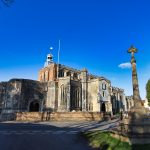
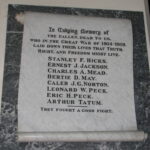
Unveiled on 8 August 1920, the Village Memorial to those who Gave Their Lives in The Great War can be found in the South Aisle of St. Mary's Church. It contains the names of 65 men from the village (or whose close family lived in the village) who lost their lives in the Great War, or shortly afterwards as a result of their wartime service.
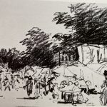
A rare sketch of East Bergholt done in the late evening of 10 August  depicting the back of East Bergholt House, home of the artist's father Golding Constable, showing the grain store.
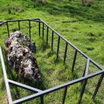
Thought to have been bought down from Scotland or Scandinavia during the last Ice Age, this impressive Glacial Erratic Boulder on the corner at Bakers End.
This area is a well-defined triangle formed by Quintons Road, Woodgates and Heath Road containing historic open space and many historic buildings.
Most of the land on the North side of Quintons Road also falls into this category
In addition, the land from the end of Gaston Street, along Heath Road from the Carriers pub to the Hare & Hounds pub, is worth also of conservation area consideration, together with the allotment land at the rear.
Originally unveiled on 9 April 1920 in the Village School at Burnt Oak, the Roll of Honour records the names of 342 men from East Bergholt - or with close family connections to it - who served in the Forces during the Great War.
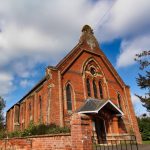
In 1644 at the height of the Civil War, the Puritans of the village declared their rector to be 'malignant' and replaced him, eventually leading East Bergholt to have a licence for a 'dissenters' chapel and from which this non-conformist and Independent Church was formed in 1672.
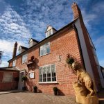
Historic "Red Lion" pub in the village centre, recently converted into the "Lion Brasserie"
This section runs from the village centre at the Gaston Street junction, from The Gables* along the western side of Hadleigh Road to the junction with Hughes Road (* The Gables is a listed building which sits in the current Conservation Area).
While the eastern side of the road is not for conservation area consideration, (mainly lined with set-back 20thC and 21stC houses and the school playing field), it does contribute to the attractive natural tree cover that characterizes the road.
Together with the western side, the mature trees create a pleasing “tunnel†effect over the road at all seasons. The tree-lined frontages for historic buildings such as Gatton House and Ackworth House, which are spaced out along the road, with driveway entrances such as the one for the Gattinets business units. Generally, these historic buildings are only partly visible from the road where the vegetation predominates, with no pavement on this side.
At the top Hadleigh Road intersects with Hughes Road and Elm Road, before it continues northwards. Here there is a large open meadow in front of the historic Allens Farmstead, and features the gated drive to the Grade 2* -listed “The Lodgeâ€, which is not really visible from the road.
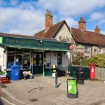
General store in the centre of the village, with free parking nearby, next to the Red Lion Brasserie.Â
Open 7 days a week 07:00-22:00
The first of the Great War memorials in the village, were unveiled in the Congregational Church on 21 March 1920. These were not memorials to the men from the village as a whole, but commemorated those connected to the Congregational Church and its Sunday School.
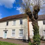
A view from The Street towards the home Golding Constable built for his family in the heart of the village 'East Bergholt House'
A 12th Century Augustinian Priory on the border between East Bergholt and Bentley, founded in 1188 by Wimer the Chaplain (servant of Henry II and sheriff of Suffolk and Norfolk), and was in use until Cardinal Wolsey’s downfall in 1525.
Â
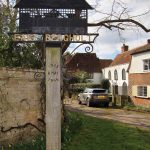
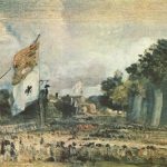
The Green, the heart of the  village and for many years prior to ‘enclosure’ in 1817 a meeting place for exchange of trade, the village fair, gatherings for celebrations, coronations, wars, or as depicted in John Constables ‘Celebration of the General’ 1815, a procession held for the poor people in the village to celebrate the peace treaty, however today all that remains of the green is this tiny patch of grass which houses the village sign.
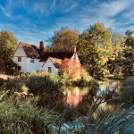
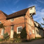
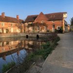
Flatford itself is a small cluster of buildings on the banks of the River Stour to the south of East Bergholt. It includes the famous Flatford Mill, together with other historic structures such as the lock, the bridge, the Granary, Valley Farmhouse and Willy Lott’s Cottage.
It is served by Flatford Lane on the north side of the river, which runs in a loop from the crossroads at Gandish Road/White Horse Road junction downhill towards the National Trust CarPark, and then uphill to East Bergholt Church.
The area is within the Dedham Vale AONB; with cross-country pedestrian and boat access to Dedham itself. The land for consideration for Conservation Area status also comprises the fields and woods either side of Flatford Lane, and the mill-related properties on the riverside.

Opening hours
Monday-Friday
0900-1300 | 1400-1800
Saturday-Sunday CLOSED
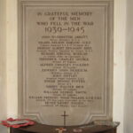
Unveiled on Remembrance Sunday 1948, the Village Memorial to those who Gave Their Lives in the Second World War can be found in the South Alcove of St. Mary’s Church. It contains the names of 13 men from the village (or whose close family lived in the village) who lost their lives in that War.
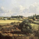
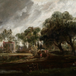
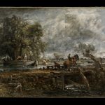
Landscape depicts the view from Constable's parental house in Suffolk in 1815, painted from an upper window or the roof of Golding Constable's house.
It depicts the kitchen garden belonging to the artist's father, looking over the fields in the centre of the village.
Like many towns and villages throughout the country, East Bergholt held an annual fair for many centuries, in fact an early record by order of the Lord of the Manor in the reign of Henry VI recorded that the bailiff should collect rents and profits from stalls ‘next the graveyard of East Bergholt Church and to answer for them’, and there were many attempts to have it banned in the 17th Century when warrants were issued for anyone who set up a booth or stall (1685).
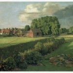
Landscape depicts the view from Constable's parental house in Suffolk in 1815, painted from an upper window or the roof of Golding Constable's house. It depicts the Flower Garden as a panorama, moving from the village at the left of the flower garden to the refectory and houses at the right of the kitchen garden.